Rachel Manderfeld, MI
GIS Applications Specialist · Information Management Professional
Connect
Skills
- Esri Suite: ArcEnterprise, ArcServer, ArcGIS Pro, ArcGIS Online, Survey123, Experience Builder & Dashboard
- Esri products: Survey123, Spatial Analysis and Hydrology add-ons for ArcGIS Pro
- Daily use of Visual Studio Code, Powershell, MS Access & Excel, GitHub
- Open Source: OpenStreetMaps, Mapbox; learning QGIS and Whitebox
- Python
- SQL
- JavaScript
- HTML
- CSS
- JSON APIs
- Self-starter. Creative problem-solver, analytical thinker who takes initiative.
- Translate between technical and non-technical project stakeholders.
- Strong work ethic and integrity. Timely and thorough.
- Collaborative team member, shares skills and knowledge with others.
- Cultivates inclusive, positive environment.
- Drafted land survey project with AutoCAD Map 3D from field notes
- Comfortable using GPS/GNSS equipment for field data collection
- Trigonometric and Differential Levelling
- GNSS and Surveying Techniques
- Adaptable to all weather conditions
- In the process of acquiring UAV / drone basic license
- PostgreSQL
- ETL and Safe's FME Workbench
- Oracle SQL Developer
- Relational Enterprise Database Development / RDBMS
- Enterprise Geodatabases and Versioning, Replicating, Archiving
- Automate GIS processes with Python, Model Builder, FME
- ArcGIS Server and Portal Services
- AWS with ArcGIS Server and Portal
- Dynamic DNS Services, Duck DNS
- ArcGIS APIs for JavaScript, REST API
- Google Cloud
- PCI Geomatica / Catalyst
- eCongition, Image-Object Based Software
- Processing with Machine Learning using PCI's Object Analyst
- Orthorectification and Digital Surface Model Extraction from legacy aerial photography
- LiDAR Remote Sensing
- Principal Component Analysis & Image Fusion Techniques
- Image Parallax and Digital Elevation Models
- RADAR Inferometry and Remote Sensing
- Spectral Indices, Image Histograms and LUTS
- Interpolation Techniques
- Geostatistical Surface Modelling
- DEMs, TINs, and 3D Visualization
- ArcHydro Watershed Analysis, Stream Segmentation
- ArcGIS Pro, Spatial Analysis Extension
- Applied Spatial Statistics
- Multi-Criteria Decision Analysis
- OLS Regression
- Least-Cost Path Analysis Techniques
- Geocoding and Dynamic Segmentation
- Network Analysis
- Led staff of 12 people and created on-boarding program for 3 external hires.
- Cultivated a positive and inclusive work environment for staff of all levels.
- Exceptional leadership and emergency response management during crises.
- Leadership with coach-approach and valued contributions of all team members.
- Provided positive feedback and encouraged others.
Modelling Canopy Height Model with LiDAR and Photogrammetric-derived Point Clouds

Using point cloud data to create a DTM and a DSM in order to calculate canopy height model.
Lake Explorer for Peterborough and the Kawarthas

Esri-based website and tools for understanding lake bathymetry and water quality indicators for lakes within Peterborough and the Kawarthas.
Chiniguchi Waterways Provincial Park Canoe Route Map

Canoe route map for navigating Chiniguchi Waterways Provincial Park in northern Ontario.
Enhanced Flow Direction Grid

Enhanced Flow Direction Grid for Ganaraska Forest. Comparison of drainage lines from ANUDEM interpolated DEM to photogrammetric representation.
Kootenay Valley Remote Sensing Image Analysis

Three different methods of image analysis using Catalyst (PCI Geomatica): Pansharpened True Colour Composite, SWIR, Standard False Colour Composite.
Ranked Habitat Analysis for Salamanders
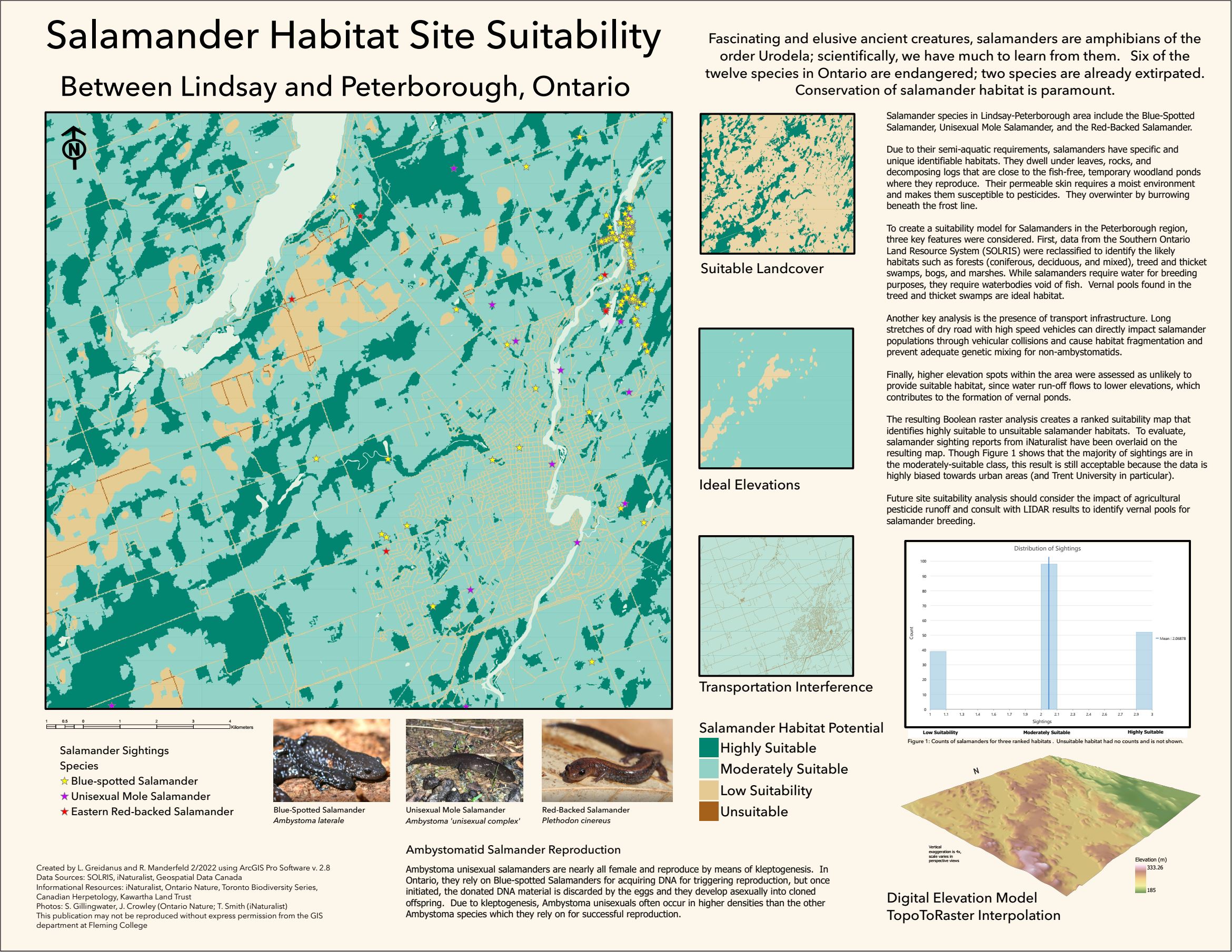
Site suitability analysis using DEM, salamander sightings, and ideal habitat data.
Supervised Classification of Oak Ridges Morraine

Supervised classification of orthophotography using PCI Geomatica / Catalyst of the Oak Ridges Morraine area.
Experience
GIS Specialist
Through Fleming College, culminating project with Kawartha Conservation. Delivered GIS-based Interactive Lake Mapping in the Kawarthas.
- Developed use-cases and project goals with client.
- Implemented GIS solutions that met goals using a re-iterative process.
- Built 3D bathymetry maps, data visualizations, user-input capabilities.
- Leveraged teamwork, solid communication, and cooperation for quick turn-around.
Branch Head, City Hall Branch
Cultivated a positive and inclusive work environment for staff and patrons.
- Managed staff of 12 people including creating a thorough on-boarding program for 3 external hires.
- Increased program delivery and program attendance by 300%.
- Demonstrated exceptional leadership and emergency response management during crises.
- Successfully guided staff through organizational and policy changes.
Public Services Librarian
Directly served hundreds of library users in fast-paced environment.
- Developed, delivered, and evaluated innovative programming for children and teens.
- Created and co-lead highly successful youth creative writing program.
- Taught computer and tech literacy workshops.
- Prioritised staff and client safety during high pressure emergencies.
Web Librarian
Led redevelopment of TPL’s teen website. Technical advisor on a nation-wide committee for a Canada-wide reading program’s website.
- Collaborated with designers, web developers and managerial stakeholders.
- Information management for a database of 2500+ public libraries in Canada.
- Developed a new, dynamic youth website and migrated data to the new platform.